

Low water in Upper Kananaskis Lake
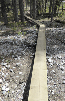 First we had a look at Three Isle Lake trail. Apart from a new footbridge at Invincible Creek and a short reroute off the bridge, the main changes occur between Upper Kananaskis Falls bridge and Forks Campground with a major reroute beyond the spring creek crossing. The new trail crosses Dead Horse Gulch, as James calls it, and the alluvial flat of Three Isle Creek via no fewer than 8 bridges of various kinds (with one more to come) and a long stretch of boardwalk. It was quite impressive. We heard that campers trying to get up to Three Isle Lake had been turned back by snow. Another couple with snowshoes were aiming for Turbine Canyon. I wonder how far they got?
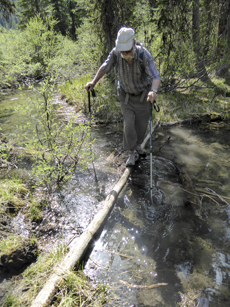 We reached Upper K Lake trail via the decommissioned Lyautey trail that shortcuts between Forks and Point campgrounds. The trail is still clear– obviously people are still using it—but has more deadfall to clamber over at the north end. The two water crossings at the south end can be crossed on skinny logs using two poles for balance!
We returned to North Interlakes Parking lot via Upper K Lake Trail. The big change here is the rerouting of the trail around Lower Kanananskis Falls. Unfortunately this new line misses out one of the major attraction of the trail! While the old trail to the falls is still a go as far as the falls, it’s been blocked off with branches at the low end Y-junction. To us it makes sense to remove the branches and erect signs at the Y-junction indicating Lower K Falls viewpoint 100 m to the left and Upper K Lake trail to the right. Maybe this is the intent?

Nearing the parking lot I took a pic of the sign at Indefatigable trail junction that warns you are entering bear terrain should you venture up that trail. Ironically, a few minutes later we passed grizzly #162 busily eating fresh greenery on the exposed flats above the lake.

#162 was happily browsing and we got past without disturbing him.

Both upper and lower Kananaskis Lakes are as low as we’ve ever seen them.


Comments on this entry are closed.
Lower K Falls is a good objective. Lyautey needs to be rerouted to avoid the wet areas and the willowy meadow where we were on the alert for bears, having noticed a digging. The trail SHOULD go south, keeping to the trees around the edge of a large shallow tarn (source of all the water), then cross fans of shale on the lower slope of Mt. Lyautey (so keeping some distance away from the meadow) and only then contour in to rejoin the westernmost section of trail in the forest.
I don’t know how old the kids are, but they may also enjoy looking at the Foch Creek resurgences, especially as the water level in the lake is so low. Or go take a look at the new trail being built around Hidden Lake.
Thanks for this detailed writeup! I have been to Rawson Lake since the flood, but not the other side of the lake and was curious where to take the kids exploring from Point Campground. We will give Lower K falls and Lyautey a try since the trail sounds navigable (and will bring your trail guide just in case). 🙂
Most of the trail repairs in the Upper Kananaskis Lake area have been completed. The main exception is the bridge over Sarrail Creek. A new one is slated for installation this summer.
Consideration should be given to re-opening Lyautey trail which was closed and the bridges removed a few years ago. It used to be a key connection between Forks and Point campgrounds. We met a couple with three small children who had taken all of a long, hot day to get from Forks to Point via the rock pile connector. Most of the Lyautey is still in good shape and only needs deadfall removing. A detour southward might avoid the creek crossings?