
Updated July, 2024.
Approximately 180 km of The Trans Canada Trail is in Kananaskis Country and it can all be hiked or biked (with a few minor diversions). The trail enters Kananaskis Country from Range Road 54 west of Bragg Creek and makes its way across the foothills over mostly well-established trails to Banff Park East Gate. There it leaves K Country for Banff via the Legacy Trail and comes back in at Whitemans Gap via the Spray River and Goat Greek, a distance of about 33 km taking the shortest options through Banff.
This short guide to the Trans Canada Trail through Kananaskis Country includes lots of links to maps, and to Trailfinder information screens where you will find more links. Most sections are described in Gillean Daffern’s Kananaskis Country Trail Guides. So get out and explore The Great Trail this summer.
So what kind of a state is The Trans Canada Trail through Kananaskis in today?
- While it all follows maintained trails, TCT signage has improved in recent years. In a few sections you will need to pay attention to your navigation.
- There is a significant gap in the route through the Three Sisters development in Canmore. Stewart Creek is still under construction and Smith Creek development hasn’t even started. It will be at least five years before the final route of the TCT is established and navigable.
- For thru hikers or bikers, there are very few campgrounds en route, and many of the available campgrounds require pre-booking. Backcountry campgrounds require a Backcountry Permit. Random Camping is allowed in Wildland Parks and Public Land Use Zones as long as you are at least 1 km from a backcountry facility or roadway. Random camping is not allowed in Provincial Parks or Provincial Recreation Areas.
Let’s look at the various sections, working from east to west.
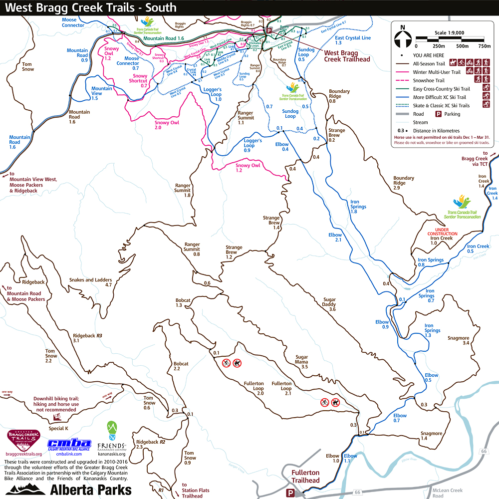
Range Road 54 to West Bragg day-use area – 7 km, s-n 304 m, n-s 256 m
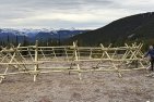
The trail enters Kananaskis Country from Range Road 54 west of Bragg Creek. Turn off the West Bragg road at a major crossroad about 1.6 km before the K Country Boundary. The official trail starts on the right after 1.6 km. There is no parking available. Head about 250 m on Iron Creek Trail along a fence line to a good old logging road. Turn left and follow the road for 1.8 km to within a few metres of the cross-country ski trail loop. A new trail, climbs for 0.6 km to join Boundary Ridge trail. See map for a better trail onto the ridge for hikers. Climb up onto Boundary Ridge and traverse it before descending easily to West Bragg day-use area. See map. In winter the wide (XC ski) alignment follows Iron Springs and the east half of Sundog to the WBC parking lot.
There are actually two Trans-Canada Trail alignments through the West Bragg Creek trail network. This is to accommodate all of the different users, especially in winter, when skiers have exclusive use of some ski trails.
West Bragg day-use area to JUMPIMGPOUND DEMONSTRATION day-use area (WELL road crossing) – 17 km, s-n 160 m, n/s 140 m
This is the longest leg of the Trans Canada Trail between access points in Kananaskis Country.
From the WBC parking lot, the summer single track version follows Braggin Rights, the east half of Merlin View and Kestrel to Tom Snow Trail.
The wide (XC ski) version follows Mountain Road, to Moose Connector, and along the north-east half of Moose Loop. Tom Snow Trail South trail comes in from the left after about 800 m. Follow the combined Tom Snow–Moose Loop for another 2.5 km to where Tom Snow heads left to the height-of-land between Bragg Creek and Moose Creek. After this point you are on Tom Snow Trail North, following for the most part a brand new trail to the access point for Jumpimgpound Demonstration day-use area. Click on Tom Snow North above to see sketch map of the access to day-use area parking, which was enlarged in 2023.

Moose Mountain from Tom Snow Trail North
If you are going straight through to Dawson day-use area, continue along Tom Snow Trail North. Arrive at a T-junction with Dawson day-use area to the right and Cox Hill – north ridge, the next leg of The Trans Canada Trail, straight on.
Dawson day-use area to Lusk Pass trailhead – 13.3 km, e-w 800 m, w/e 680 m
Up Cox Hill – north ridge to the High Point of The Trans Canada Traill and down Cox Hill – south ridge and Jumpingpound Ridge Trail to Lusk Pass trailhead.

On the summit of Cox Hill, the highest point of The Great Trail
Lusk Pass trailhead to Barrier Dam day-use area – 12.4 km, e-w 230 m, w-e 40 m
Lusk Pass trail is mainly a dark forest trail with a few steepish hills that crosses a low pass between Powderface Trail (road) and Barrier Dam. Currently logging has occurred over several areas of this section. Shortly after you cross Lusk Creek the official Trans Canada Trail turns left at a T-junction. (A shorter, rougher trail, the pre-flood route, carries straight on and joins the official trail close to Lusk Creek day-use area. See map.)
Follow the official trail to a T-junction with Baldy Pass trail and turn right. Follow “The Old Mill Road” down to yet another T-junction where you turn left on the old Lusk Pass trail to the Barrier Biogeoscience Institute field station. See detail map for the route through the field station to Barrier Dam day-use area.
Barrier Dam day-use area to Heart Creek parking at Lac des Arcs – 13.8 km, s-n 680 m, n-s 590 m
Head across Barrier Dam on Prairie View trail for 1.3 km to a T-junction with Stoney Trail. Turn left and follow it 2.5 km as it parallels the lake to the Jewell Pass trail. A little farther on is Jewell Bay backcountry campground. Turn right. The Jewell Pass trail is a forest walk alongside the creek to a viewless pass. Prairie View comes in from the right. The next trail to the right is the route down Quaite Valley to the Trans-Canada Highway. Mostly in trees, it passes Quaite Valley backcountry campground, then descends a flood-repaired section of track. Just before the highway a trail heads left to Heart Creek day-use area in 3.2 km. See map
Heart Creek parking to Wind Valley trailhead – 7.6 km, 90 m
Head west from the Heart Creek parking on Bow Link trail. Follow it, sometimes close to the highway, to George Biggy Sr. Road at Deadman Flat. The Trans Canada Trail will likely use the yet-to-be-built extension to Three Sisters Pathway on its way to Canmore.
Wind Valley trailhead to Stewart Creek pavillion. TCT map route – 7.2 km, e-w 240 m, w-e 300 m
The final route for the next section through Three Sisters Mountain Village lands is unknown. Stewart Creek area is still being developed and The Town of Canmore has recently approved an Area Structure Plan for Smith Creek.

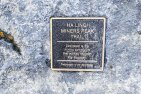
The TCT Pavillion at Mineside trailhead. Image: Alberta Trailnet before the name was changed back to Trans Canada Trail.
At present (July 2024) there are two options to get to the start of Three Sisters Pathway at a pavilion on the corner of Three Sisters Parkway and Stewart Creek Way:
1. The official route as shown on the interactive Trans Canada Trail map is a Water Trail between Three Sisters Campground at Dead Man’s Flats and Bow River Campground opposite Stewart Creek interchange on the Trans Canada Highway. This is a dangerous section of river, with a fast current and sweepers.
2. For those on foot or bike the best option at present is to use Guy Lafleur. 5.5 km.
Stewart Creek pavillion to Canmore Mineside trailhead (Bow River Bridge) – 6.8 km 50 m
From the pavilion follow Three Sisters Pathway to Mineside trailhead at the Bow River bridge in Canmore. Mineside is the site of Canmore’s TCT Pavillion.

The old Canmore Mines lamphout badly in need of restoration is close to Three Sisters Pathway

A spectacular section of the High Rockies Trail
The Trans Canada Trail leaves K Country for Banff via Legacy Trail and comes back in at Whitemans Gap ~33 km
If you want to continue on the Trans Canada Trail to Banff, cross the road bridge and head north through Riverview Park to Engine Bridge. Frequent trail signs indicate the route. Turn right and follow the old rail grade to Railway Avenue and on to Highway 1A. Head north along it to the start of the Legacy Trail at the Travel Alberta Visitor Information Centre (3.5 km). From here it is 4.5 km to Banff Park East Gate where the Trans Canada Trail leaves Kananaskis Country for Banff. It comes back in via the Spray River and Goat Creek at the Park boundary near Goat Creek trailhead.
High Rockies Trail Whiteman Gap to Elk Pass and into BC – 82 km
Visit our mini-site for a full description with maps and track log of The High Rockies Trail.

Comments on this entry are closed.
Re section between Wind Valley and Stewart Creek Pavilion: Why is it that QuantumPlace Developments has not included the Trans Canada Trail in its area plans? Have the developers and Alberta Trailnet ever got together on this?
It makes sense to take the Trans Canada Trail through their lands, perhaps based on Guy Lafleur which is outside of any wildlife corridor. The present plan to take the trail along the old mine road inside the wildlife corridor will never fly.