
This is yet another update of my 2016 article. Since then Friends of Kananaskis Country volunteers have brushed-out more kilometres of trail and created a couple of new ones. Here are some suggested loops for snowshoers to enjoy and an up-to-date sketch map of the system that you can print out on letter-sized paper to take with you to create your own loops. See Winter Trails under Trailfinder Trail Lists in the lefthand column of this page for more snowshoe ideas and more detailed sketch maps.
Some short loops from Chester Lake parking.
The addition of the new Sinter trail allows for a number of short loops from a very easy 1.7 km trail suitable for children learning to snowshoe to longer loops taking in Snowdrift, Sinter, Frost Heave and the High Rockies Trail. Sinter is easiest from west to east as the descent from the Snowdrift end is quite steep. See the sketch map for Mount Murray Viewpoint.
South Sawmill Loop 3.8 km, 80 m elevation gain
The trail starts at the winter trailhead at the far end of the parking lot. Bear right and about 200 m from the trailhead turn right up the obvious trail. Follow it to a junction where the summer High Rockies Trail comes in. In early winter, before the snowplow bank gets too high you can use it to access the loop. To make best use of the limited views snowshoe the loop anti-clockwise .
Sawmill Snowshoe Loops 5.1 km, 155 m elevation gain
Immediately north of Sawmill parking are parallel trails allowing for three loops of of varying distances. The 5.1 km outer loop is a pleasant snowshoe best done clockwise. The western leg winds up along the open, badly flood-damaged James Walker Creek, scenic in spring when the creek starts to melt out.The return leg, once you have crossed the creek, is in trees all the way back.
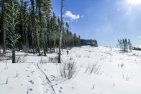
Sawmill South Tour 5.9 km, 240 m elevation gain extends the above Sawmill Snowshoe Loops thanks to Friends brushing out Wind Chill and building the new connector, Sun Cups. This is a more challenging loop as Wind Chill is unrelentingly steep for most of its length and most people will prefer to climb, rather than decend it on snowshoes. Whicheve way you do it, the James Walker Creek leg, as mentioned above and shown below, is the most scenic part of the loop.

Alongside the badly damaged James Walker Creek.
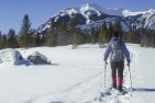
Mount Murray Viewpoint 6.0 km, 260 m elevation gain
Best done as a figure-8 loop heading along Snowdrift trail for 2.6 km to a junction just after the trail turns sharp left above Headwall Creek. A steady, moderately steep ascent leads to a viewpoint trail just before the high point. Thanks to Friends volunteers, you can continue down the brushed-out trail, steep in places, to Snowdrift. Turn right, and in about 100 m turn left down the new Sinter Trail that takes you down to a long, open fen, brushy in early winter and very wet when not frozen. At the west end of the fen turn right to get back on Snowdrift or left to the High Rockies Trail. Either way gets you back to Chester Lake parking.
Graupel Loop 7.7 km, 212 m elevation gain
The construction of the High Rockies Trail has created an easy loop from Sawmill trailhead that we have named Graupel Loop. It can be hiked in summer and snowshoed or skied in winter.
Sawmill North Tour 10.8 km, 480 m elevation gain
This tour from Chester Lake parking is one of the more open and scenic snowshoes in the Sawmill Area. It follows Snowdrift to about 700 m past the Headwall Lakes junction where a recently (2019) cleared trail, Whiteout, heads due south before turning sharply NW to the High Rockies Trail which is followed back to the parking lot.
While shorter than the Grand Tour it has more height gain and is probably best done on a sunny day in spring, and preferably when someone else has broke trail!
Sawmill Grand Tour 13.3 km, 345 m elevation gain
Starting from Sawmill parking this 13.3 km outer loop (shown as a dashed line on our map) gives you a “grand tour” of the Chester–Sawmill area. It can also be skied on touring skis by those willing to ski on snowshoe tracks and to to break trail if necessary. The trails in this area are not groomed. It can be extended by going all the way to Chester Lake parking, an extra 2.8 km — but why would you want to!
One way Chester to Sawmill
With multiple vehicles you can, of course, snowshoe or ski from Chester to Sawmill (Sawmill is about 75 m lower than Chester parking). The upper, most scenic trail, is Snowdrift at 9.1 km. The lower one Graupel–High Rockies is 7.1 km.
Click on map below for larger version that you can print on letter-sized paper.


Comments on this entry are closed.
A bit of history. SLS started logging the area in 1953, building the mulltitudes of roads we have today. In 1983, Gill, Albert Mazzuchi and I skied the old roads looking for a backup site for running the 1984 Western Canadian XC Ski Championships which were slated for West Bragg. In the Fall of 1983 a work crew from Foothills Nordic Ski Club cleared 10 km of trails in the area of the Current Sawmill Loops and ran the Western Canadians out of Sawmill using a rented motorhome as a base for timing and results. No computers in those days. Four or five of the original work crew ended up in senior positions for the 1988 Olympics. Later Parks cleared more trails to create the basis for the trail system we have today. The Sawmill trails were not ideal for racing, so Mount Shark trails were built and used for training Olympic volunteers until Canmore Nordic Centre was first used for the Nordic Combined test events in the fall of 1986.
Lynda, the distance is 2.7 km. I have altered the sketch map to make the correct distance more obvious.
Hi Tony
I enjoy your blogs and Gillian’s books! I do have a query regarding the Sawmill trail loop. Your sketch map indicates that the outer sawmill loop is 1.9 km, yet the Alberta Parks downloadable brochure says it is 2.7km, and a sign at the trail indicates it is 2.5 km. I”m wondering if you know what the correct distance is. I am the author of the book, Take A Hike With Your Children, and I am writing a blog on some Family Friendly Snowshoe trials, and I would love to know the correct distance to post in my blog.
Thank you for your time.